

Location awareness is becoming a key feature in mobile information systems. It is now no longer an additional feature and is integrated very tightly into systems such as fleet management and other ITS systems. In the last few years GPS has grown to be the most widely used technology for determining the position of goods and vehicles and will remain a key technology in location-aware applications and services in the future.
In addition, a tight integration of GPS technology into ITS systems has raised new requirements for GPS receivers. Most prominent amongst them are significantly reduced size and increased flexibility. At the same time the customer faces a shortening market window-of-opportunity with every new product design. In such a situation, many designers have to decide between the flexibility (and possibly highest possible integration) of a proprietary receiver design based on one of the many GPS chipsets available on the market and the fast time-to-market which can be achieved with the utilisation of an off-the-shelf receiver.
In this article, the author looks at the trade-off between the ease-of-use of standard OEM GPS receivers and a flexibility of a proprietary receiver design. Discussion begins with the development of a highly integrated GPS system, which has been developed for the use in bird research. The article concludes that for most systems, the utilisation of miniaturised standard hardware components with configurable interfaces and customisable software is the optimum solution, as it combines highest possible integration and design flexibility with fastest possible time-to-market.
The project
One of the most fascinating topics in bird research is the navigation capabilities of birds, especially homing pigeons. Ornithologists all over the world are trying to figure out how these birds navigate and what sense of orientation enables them to find their way home from places as far as 320 km away. You might think: "Why should we bother? What does this have to do with ITS systems? We basically want to know where our trucks are!"
At first sight, behavioural studies of birds might not have too much in common with fleet management and traffic technology. But the technical challenges implementing a miniature flight recorder are very well suited to demonstrate the advantages of the integration of a complete system on a GPS receiver module. Size and weight restrictions require an extraordinary high level of integration, which results in reduced external component count. A welcome side effect is a considerable reduction of the total system cost.
A GPS receiver basically consists of an RF front-end, a correlator ASIC and a small processor system with SRAM and flash (see Figure 1). The solution of the equations to calculate the position in real-time requires a powerful processor. Therefore, the processor will be idle most of the time, if the position information is not required at the highest frequency possible. A cost-effective system design will take account of this and uses the free resources, in order to minimise external component count while maintaining or even enhancing system functionality.
Miniature flight recorder
Prof Lipp, head of the research group for Neuro-anatomy and Behaviour at the University of Zurich brought up the idea of a miniature GPS flight recorder. His research group is internationally known for their behavioural studies on homing pigeons. They were looking for a device to get a new edge on their research regarding the orientation and navigational skills of the birds. Until now there where only simple flight recorders, which were based on a compass and these could only record the headings during the flight. With a GPS receiver much more detailed data could be collected. Through the analysis of this data they hoped to get better insight on the behavioural patterns and cognitive skills of pigeons. In a joint project of the Institute for Anatomy of the University of Zurich and the Electronics Lab of the ETH Zurich, two students developed a flight recorder for homing pigeons. The idea was to attach a small box to the back of the bird that captures and records position, altitude and time. Once the bird has returned home the recorded data is transferred to a PC for analysis.
Basically the flight recorder would consist of a power supply (battery or accumulator), GPS receiver, GPS antenna and a datalogger (Figure 1).
A pigeon is capable of carrying about 40 g of weight for several hours, which is what they usually carry as food during a flight. Therefore the total weight of the system was not to exceed 40 g. The size is determined by the size of the back of a pigeon. A module of 40 mm x 60 mm would fit on the bird's back. (Figure 2) Due to these mechanical constraints the highest possible level of integration was mandatory.
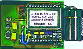
With its weight of 8 g and the measurements of 30 x 30 mm the GPS-MS1 was the ideal candidate for this application. Power consumption was a major concern, as in most mobile applications. The GPS-MS1 supports a power save mode. In this power save mode the receiver acquires a position, stores it to the flash and automatically shuts down. This process takes about 1 s. During the rest of the period the system remains in standby at a power consumption of 500 µA. Using a position up-date period of 5 s the GPS-MS1 would operate up to 8 h on a CR3 battery. This battery type proved to be the one with the best capacity/weight ratio. To reach the highest integration possible for the antenna a ceramic patch antenna with a ground plane directly on the PCB was used.
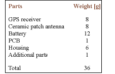
The whole receiver is packaged into an ultra-light composite housing. The battery, the GPS receiver and the ceramic patch antenna contributes the most to the weight of the total system. The weight of the complete system including battery, antenna and housing is currently 36 g (see Table).
The datalogger's capabilities
The GPS-MS1 contains 1024 KB flash memory of which 700 KB are available for custom use. These free resources can be used to implement a datalogger directly on the GPS receiver. This internal datalogger can write position information, altitude, velocity, time and number of satellites used for navigation to the on-board flash. After a flight the recorded data is downloaded to a PC through a serial interface. There the data is visualised and analysed. The size of a regular data record is 9 x 16 bit words. The datalogger is configured through the serial interface. Configuration software enables one to set the logging interval as well as filter parameters that define whether a position fix should be stored to the flash or not. This filter minimises the number of stored positions, while maintaining enough information to reconstruct a trace. The filter checks the minimum distance between two logs before storing a data record. This prevents the receiver from fill the flash should the tracked object move very slowly or stand still. A data compression algorithm further increases the number of data records that can be stored in the flash. Data is compressed by only storing the difference from the last position. Using all these features the datalogger is able to store up to 100 000 data records. The datalogger also offers the possibility of storing the states of twelve digital I/Os, together with a time tag. This allows the storage time and position of external events like starting an engine or pushing a panic button.
It flies...
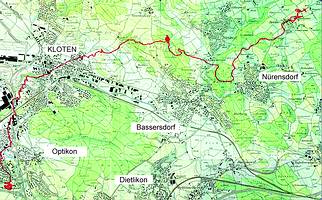
For the first test flights the pigeons were trained with dummy units of the same size and weight as the flight recorder. After that training period the birds did not seem to take any notice of the additional weight and first flights of 2-5 km (see Figure 3) showed very encouraging results. For the first time ever recording the flight of birds over long distances (>100 km) was made possible.
Customised operation of the GPS receiver
In most of the AVL systems the main focus is on the integration into an existing system as opposed to minimal power consumption and small size. The software customisation kit (GPS-SCK) is a software development platform for the µ-blox receivers that offers the flexibility needed for a close integration of the receiver in the complete system. This can save the developer from the tedious task of designing a proprietary GPS hardware. It speeds up development cycles and allows the system integrator to focus on the functionality of the complete system instead of getting caught in the time-consuming task of acquiring know-how of the base technologies. The software customisation kits take advantage of the features of the GPS receiver in order to perform basic control and communication functions.
The integrated datalogger marks the start of a series of software enhancements that will be available as ordering options. These enhancements will simplify the architecture of a complete AVL system. The communication of this information to a central office is becoming mandatory in a lot of applications. In the near future, these GPS receivers will be able to communicate directly with a GSM modem. They will then be able to initiate SMS messages or a data connection to a host PC. Various predefined events, such as entering a predefined area or pressing a button, will trigger the receiver to transmit its position.
About µ-blox
µ-blox was founded in 1997 as a spin-off company of ETH Zurich. From the beginning, the focus of µ-blox was to provide electronic sub-systems for new and innovative markets. µ-blox designs and produces standardised building blocks that enable product designers to create new and innovative products in a very short timeframe. The main focus in the GPS product line is to provide best GPS performance in a module that overcomes size constraints and therefore puts GPS into systems where they were previously not utilised. Off-the-shelf modules with customised software provide a minimal cost solution with highest possible flexibility in product design.


© Technews Publishing (Pty) Ltd | All Rights Reserved
 printer friendly version